Como membro do Comité Internacional dos Arquivos Militares
que integra aquela Comissão, apresentei uma comunicação sobre a cartografia
portuguesa dos descobrimentos, que foi muito apreciada.
O texto foi evidentemente
apresentado em Inglês e não vejo outra forma de o deixar aqui. As minhas desculpas
àqueles que não dominam o idioma.
Neste dia especial, acrescento este texto especial...
 |
| Earth, XVIth century, Pedro Nunes. |
The historiography of the discoveries has been trying
to find out the reasons to explain the Portuguese priority position.
A series of conditions seem to have concentrated in
time and place, thus allowing Portugal to accomplish a major maritime adventure
that changed the face of the world in the XVth and XVIth centuries. Seen today, one might say that this adventure
paved the way for the construction of the first global village of the Modern
History.
 |
| View of the Ocean, in the Portuguese coast. |
Portugal has always enjoyed a privileged location in
the westernmost part of Europe, with a long line touching the Ocean, good harbours
and navigable rivers; on the other hand, Castilla and Léon hampered the
relationship of Portugal with the rest of Europe. The Sea became an invitation,
a necessity and a way out.
 |
The
plantation of the Leiria Pinewood,
in the centre of Portugal, mid XIIIth century,
would supply
the wood required by the naval construction.
|
A number of political and economic conditions were
also essential, a summary of which is as follows: Very ancient and frequent
contacts with the Muslim civilization; power centralization tradition, with
direct connection to the King; complete definition of the Kingdom territory.
 |
The
caravel was a light sailing ship especially
conceived to explore the African coast.
|
In addition: The birth of a new political power with
the Avis dynasty, after the people’s revolution of 1383-1385; wealthy religious
orders, in particular the Order of Christ (former Templars); and money economy,
with sufficient capital accumulation.
The main social conditions associated with the causes
of the Portuguese expansion can be summarized as follows: Portugal had a population
of 1,200,000 inhabitants, deeply
connected to the sea; the territory was
completely occupied, with no space being left to the new nobility, with
bourgeoise origins; since the early days
there was an active bourgeoise class, with a strong relationship with Europe, especially with
England, Flanders, Italian Republics and Hanseatic cities, and with Morocco;
until the XVth century, a distinguishing quality of the Portuguese society was
the tradition of religious convivence, in particular with Christians, Muslims
and Jews.
 |
The
Jeronimos Monastery, in Lisbon,
built in the XVIth century, is a
symbol of the
connection of the discoveries with the catholic religion.
|
In any case, in religious terms there was still a
remnant crusade spirit and had emerged the idea of association with the
semi-fabulous kingdom of Preste João, somewhere in Africa.
 |
| Usage of balestille, a device to measure the height of the stars. |
However, nothing would be possible without a number of
technical conditions capable of supporting the long-course navigation. Among
them, a special reference to the following ones: The maritime experience in
general; the tradition of naval
construction that made it possible for ships to be adjusted to the African
coast and to the Atlantic Ocean; the
ability of the military organisation, including the manufacture of
weapons; the knowledge of astronomy and cartography.
As far as the Nautical Science and the expansion and European navigations cartography are concerned, special reference should be made to the following important milestones: Firstly, the Portulan chart (crucial to the navigation in the Mediterranean sea and the European coasts), whose maps were introduced in the XIIIth century and were still used in the XVIth century; the need to develop the astronomic navigation and the knowledge of latitude to support the navigation in the Ocean, progressively used in the XVth century; the discovery of loxodromic and the Mercator projection, that corrected the mistakes of the ptolemaic vision of earth; and it was not until late in the XVIIIth century that it was possible to get to know the longitude.
 |
| First page of the “Treaty of the Sphere” by Pedro Nunes, published in 1537 dealing with the theoretical basis of the representation of the Earth, fundamental to the Mercator studies. |
 |
| Portulan chart of the Mediterranean, predecessor of the navigation in the Atlantic Ocean. |
Portulan charts can be characterized as follows: Flat
representation of the earth surface (Ptolemy); information to the navigation; drawing
up of coast lines, ports, bays, capes, low grounds, estuaries and villages; they
include course line networks, a single distance scale and have no latitude/longitude; they were used from the XIIIth century to the XVIth century; the
charts prior to the discoveries represent in particular the Mediterranean sea,
the Western Europe up to Great Britain and a small strip of Western Africa up
to the Cape Bojador; the first Portuguese navigations were made with the help
of the Portulan charts as far as Madeira and the Canaries islands.
 |
| Another Portulan chart of the passage between the Mediterranean sea and the Atlantic ocean. |
Other steps were necessary to go ahead with the ocean navigations: Investigate the wind regime; carry out the hydrographic survey of the African coast; adjust the ship and the sail, thus allowing the close-hauled sail; testing the round trip in the open sea, with the western winds.
 |
| Special reference to the influence of the wind direction on the usage of sail. |
In order to take those steps, Portugal assembled a
number of experienced technicians and scientists as well as capable men such as
cosmographers, cartographers and pilots, in order to carry out the ocean
voyages, develop the hydrographic survey and the cartographic representation of
the discovered lands, having as a probable starting point the usage of charts
produced by the Mediterranean schools.
The Portuguese cartography of the XVth century can be summarized as follows: Existence of a Portuguese cartographic school; there are few Portuguese charts known, although there are countless documents referring to them; the charts drawn by cartographers from other countries reveal that their knowledge is based on the Portuguese discoveries.
Some of the most important maps of the XVth century,
still existing: Andrea Bianco (1436), Gabriele de Valsecca, of Mallorca (1439),
Catalan world map (1450), Fra
Mauro (1459), Gratiosus Benincasa (1468), Andrea Benincasa (1476), Cristoforo Soligo (1486), Martellus (1489).
 |
| World map by Andrea Bianco representing the Mediterranean sea and
Europe and a passage through the south of Africa, dated 1436, Biblioteca Nazionale Marciana, in Venice. |
 |
| Catalan world map, ca. 1450, Estense Library, Modena. |
 |
| Fra Mauro (1459), Biblioteca Nazionale Marciana, Venice. |
 |
| Graciosous Benincasa (1468), British Library. |
 |
| Martellus World-Map, 1489, British Library. |
This last map, displaying already the southern passage of Africa, could only have been drawn up based on a Portuguese map after the expedition led by Bartolomeu Dias (1487-1488).
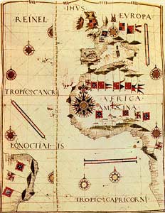
Other significant maps ought to be mentioned, such as: Modena anonymous map, c. 1471; Pedro Reinel map, c. 1485; Jorge de Aguiar map, 1492.
 |
| Modena Anonymous Map, c. 1471, Estense Library, Modena. |
 |
| Pedro Reinel, 1485, Gironda Library, Bordeaux. |
 |
| Jorge de Aguiar Map, 1492, Library of Yale University, USA. |
“On carrying out voyages in the open ocean, without catching sight of land for several days, the route navigation reveals its insufficiencies to point out the ship’s position with a minimum precision”.
Under these conditions, new challenges arose to the
pursuit of the sea travels, a breakdown of which is as follows: Astronomic
navigation in the Atlantic ocean; latitude determination; correction of the
North-South way in the ship route; knowledge of the Atlantic physical agents; manufacture
of ships with good nautical qualities; embryonic astronomic navigation, based
on the Polar Star and the Sun regiments.
In short and as far as the XVth century is concerned, one might say that: The Portulan charts are less and less suitable to the navigation in the Atlantic ocean, with the need of latitude scales through astronomic observations; it is therefore necessary to revise the cartography of the known regions, which demands the contribution of the most important Portuguese hydrographers and cosmographers such as Duarte Pacheco Pereira and José Vizinho, thus leading to the “first modern survey by latitudes of the African coast”.
 |
| The Astrolabe, an instrument used to measure the
altitude of the sun and other stars, with the purpose of determining the latitude. |
In short and as far as the XVth century is concerned, one might say that: The Portulan charts are less and less suitable to the navigation in the Atlantic ocean, with the need of latitude scales through astronomic observations; it is therefore necessary to revise the cartography of the known regions, which demands the contribution of the most important Portuguese hydrographers and cosmographers such as Duarte Pacheco Pereira and José Vizinho, thus leading to the “first modern survey by latitudes of the African coast”.
As regards the last part of the XVth century, the
following items should be stressed: The beginning of the Southern Cross
regiment – Pêro Anes and João Lisboa, in 1507; the Portuguese ships cross the
Atlantic ocean in all directions; João Vaz Corte Real and his sons travelled to
the Terra Nova in 1472; Vasco
da Gama arrives in Índia in 1498; Cabral lands in Brazil in 1500.
Past the XVIth century, an intense transient hydrographic and cartographic activity takes place, of which are known small-scale illuminated maps only, unsuitable for navigation. Around 1520, a remarkable Portuguese nautical cartography school is in full activity.
Past the XVIth century, an intense transient hydrographic and cartographic activity takes place, of which are known small-scale illuminated maps only, unsuitable for navigation. Around 1520, a remarkable Portuguese nautical cartography school is in full activity.
 |
Jorge
Reinel map, of 1540, with the African
coast and the Northeast
of Brazil,
National Library of Florence.
|
Gonçalo Coelho carries out a monumental hydrographic
survey of the coast of Brazil; in 1511, the Portuguese explore the Insulindia;
Afonso de Albuquerque conquers Malaca in 1511; the systematic survey of the
hydrography in the Far East is carried out; in 1513 the Portuguese arrive in
China; in 1543 they reach Tanegashima, in Japan; the most important
cartographers of this period were Pedro Reinel and his son Jorge Reinel, Duarte
Pacheco Pereira and Francisco Rodrigues.
 |
| The fleet
of Pedro Álvares Cabral that, on its trip to India, “passes by” Brazil. |
 |
| Sketch
of a book by Francisco Rodrigues of 1512-1514 made on his visit to the Indonesian islands, French National Convention Library. |
During the second half of the XVI century, the
Portuguese nautical cartography reaches its matureness thanks to the following
factors:
Technical rigour; high artistic sense; opening of the
unknown world to the other European maritime nations; embellishment of the
charts thanks to the help of the illuminating artists who ornament the
mariner’s compass card in an impressive way, trunk maps, ships, landscapes,
animals, humane figures, cities, fortresses and flags.
Cartographers of the XVIth century:
Lopo Homem - He was the first great cartographer of
this phase, his most famous work being the world map of 1519. It seems to have
given way to the Atlas (Miller) that is kept in the National Library in Paris.
 |
| World map by Lopo Homem, 1554, the first one to include Argentina, Institute and Museum of the History of Science, Florence. |
Pedro Nunes – some of his important cartographic
contributions:
He introduced the navigation by the rhumb line,
following the same cardinal direction, called loxodromy by Snellius; he created
the technical solution to the flaws of the nautical charts, namely the fact
that the parallel degrees were bigger than the correspondent ones in the
celestial sphere.
The
main Portuguese cartographers are the following: Lopo Homem, Diogo Homem, Luís
Teixeira, Jorge de Barbuda, Pedro Reinel, Jorge Reinel, Bartolomeu Velho, Sebastião
Lopes, João Lavanha, Fernão Vaz Dourado.
 |
World
map by Lopo Homem, 1519 (Miller Atlas), National Library, Paris.
|
 |
Atlantic
Ocean, by Diogo Homem, 1558, British Library, London.
|
 |
Atlantic
Ocean, Europe, Africa and Americas,
by Sebastião Lopes, 1558, British Museum, London.
|
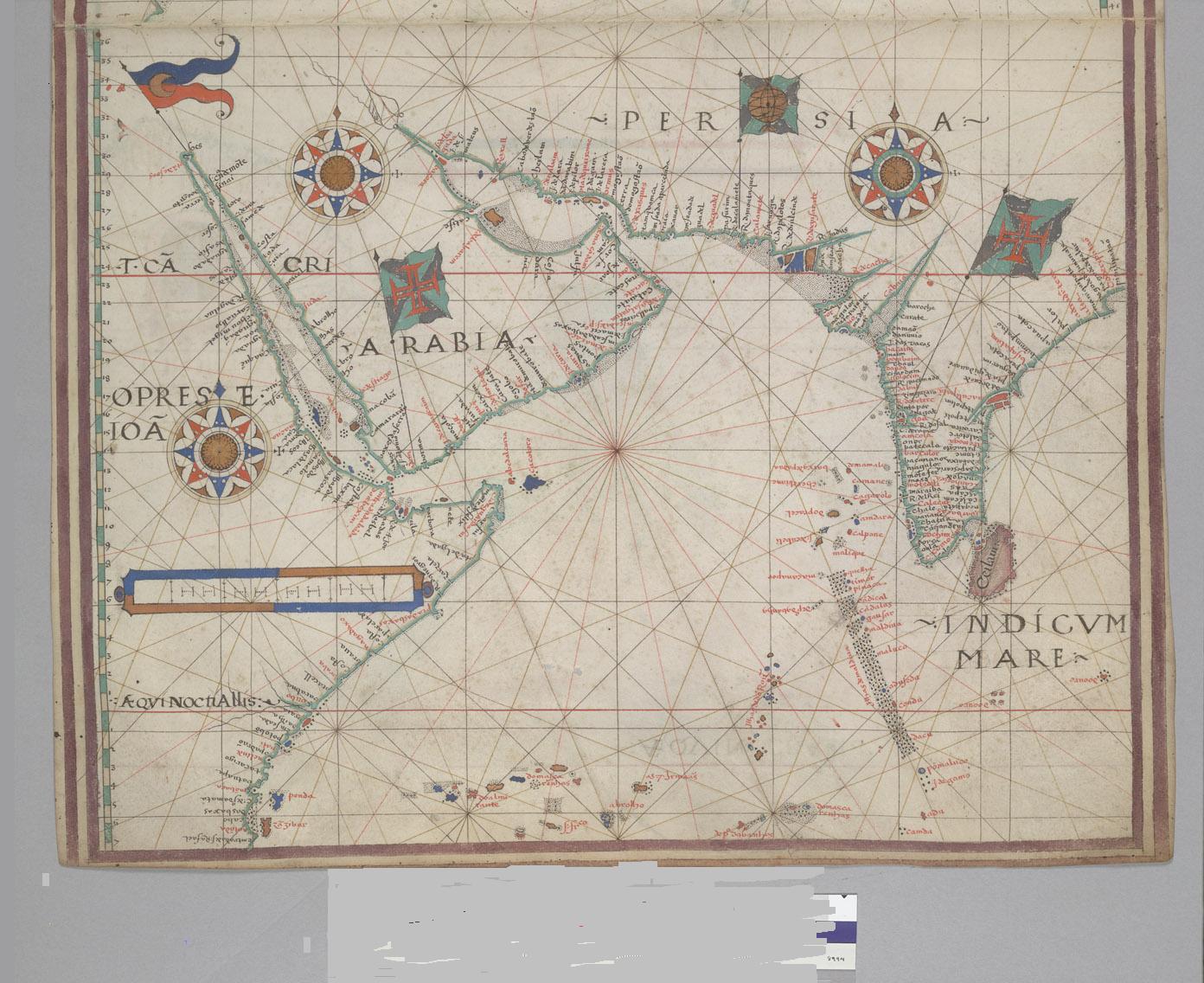 |
Orient
and Indic Ocean, by Bartolomeu Velho, 1560
Hountington
Library, San Marino, California, USA.
|
 |
| Sumatra Island and the Far East, by Fernão Vaz
Dourado, 1568, National Library, Lisbon. |
 |
World
map, by João Baptista Lavanha, 1597,
National Library,
Turim.
|
 |
Atlantic
Ocean, Africa and Americas,
by Luís Teixeira, 1600, National
Library, Florence.
|
 |
| Guanabara Bay (Rio de Janeiro) by João Albernaz,
1626, Brazilian Historical and Geographical Institute, Rio de Janeiro. |
The decline of the Portuguese nautical cartography started late in the XVIth century, in particular after the creation of the Iberian Union in 1580.
Nevertheless, the XVIIth century saw important
contributions by many of the most famous cartographers of that period: Luís
Teixeira, António Sanches, João
Antunes Tinoco, João B. Lavanha, João T. Albernaz II, P. Teixeira Albernaz.
 |
South
America, by António Sanches, 1641,
National Library of the
Netherlands, The Hague.
|
 |
| Representation of the
Tordesillas line. In 1494, the Tordesillas Treaty divided the World in domains: the lands to the east would belong to Portugal and the lands to the west to Spain. |
In general, the works produced in Portugal were copied
and quickly divulged to the other European countries that hired the services of
famed Portuguese cartographers, who would create masterly works.
Among
others, the Portuguese cartographers mentioned below have worked in Spain: Jorge
Reinel, Diogo Ribeiro, Jorge de Barbuda, João Baptista Lavanha, Bartolomeu
Lasso, Pedro Teixeira Albernaz.
The following cartographers have distinguished
themselves in France: Jorge
Reinel, João Afonso, Bartolomeu Velho, André Homem.
The following cartographer made himself noteworthy in
England and Italy: Diogo Homem.
Among the works comissioned abroad and carried out by Portuguese cartographers, a special word to the most famous and most important chart “due to the information supplied on the geopolitical conceptions of King João II, the development of the navigation techniques, the hydrographic surveys and the cartography of the African coast” – the so-called Cantino Planisphere.
 |
| Cantino Planisphere, 1502, Estense Library, Modena. |
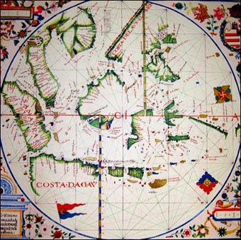
 |
| Chart with the Brazil coast
and fleur-de-lys, by Lázaro Luís, 1563, Lisbon Academy of Sciences. |
In short, the most relevant innovations introduced by the
Portuguese in the nautical cartography are the following:
Introduction of the latitude scale in Pedro Reinel’s
charts (1504 and c. 1510);
Introduction of the inclined latitude scale in Pedro
Reinel’s chart (c. 1504) in order to make navigation easy in the Terra Nova
region, due to the huge magnetic declination values;
A coast outline more adjusted to reality;
The drawing up of hydrographical plans by D. João de
Castro in 1538-39;
Longitude graduation in a nautical chart by Jorge Reinel,
in 1519;
Usage of fleur-de-lys to point out the North in the
mariner’s compass card;
First study of the characteristics of the navigation
charts, with improvement hints, by Pedro Nunes, 1537.
 |
Reproduction of
local life, in a Brazilian chart.
|
Between 1434 and 1559, a total of 125 years, that is, from the crossing of the Cape Bojador to the André Homem chart produced in Antwerp:
African coast survey, including Madagascar – 27,000 Km;
Asian coast survey – 21,000 Km;
Malaysia islands – 5,000 Km;
Brazil – 7,000 Km;
Total surveys – 60,000 Km;
Annual average – 500 Km.
The Portuguese navigations of the XVth and XVIth
centuries faced difficulties that would only be overcome by experience and a
great commitment and adaptation
capacity:
Unsuitable vessels;
Diseases;
Nourishment;
Shipwreck;
Relations with aboriginals;
Unrigorous instruments.
In spite of the decadence mentioned before, compared to the XVIth century the cartography of the XVIIth century was characterized by an intense hydrografic activity of the Portuguese in Brazil as well as by remarkable improvements in the representation of relief, rivers, local data, coast lines and number of probes. João Teixeira Albernaz distinguished himself with this work.
 |
| Types of vessels used by
the Portuguese during the discoveries and their profiles. |
In spite of the decadence mentioned before, compared to the XVIth century the cartography of the XVIIth century was characterized by an intense hydrografic activity of the Portuguese in Brazil as well as by remarkable improvements in the representation of relief, rivers, local data, coast lines and number of probes. João Teixeira Albernaz distinguished himself with this work.
To conclude, a special reference to the
work of Pedro Teixeira Albernaz and his most important cartographic “monument”
of the XVIIth century. Commissioned by Filipe IVth, he carried out a very
thorough list under the title of “Descripción de España y de las costas y
puertos de sus reinos” (Description of Spain, the coasts and harbours of its
kingdoms), with general and particular
charts of the coasts and harbours of the Iberian Peninsula, assuming the
characteristics of an atlas of their time.
Completed in 1634, although never published due to its
strategic value, this document includes a general map of the Iberian Peninsula,
making the introduction to the work;
Each province and kingdom contain a general view of their
coasts and the specific charts of their most important harbours;
The Portuguese coast is worked out in detail, resulting
in 20 charts, not only for the fact of being familiar to the cartographer but
also for its systematic survey;
The scales of the 88 partial charts range from
half-a-league to three leagues;
The cartographic representation of the coast is a flat
projection, without reference to the meridian and parallels;
The drawings are in perspective as if the cartographer
were observing the coast from a high spot, in the sea. Typical of the
Portuguese school of nautical cartography, this privileged position not only
allows the coast survey but also the examination of morphological aspects;
The atlas ends up by a spectacular world map.
It became lost (except for the "literary
description") until recently, when was found in Vienna. It is in the Austrian National Library.
Just another word to tell you that the Portuguese cartography would see
another magnificent period as from the XVIII century thanks to the works
carried out in Brazil, in the East, in Africa and in Portugal. The first modern school of fortification and
architecture was established in 1647, the Portuguese military engineers
distinguishing themselves in activities such as the survey of wide territories,
the construction of cities and the cartography.
Thank you very much for your attention.
Magnífico! Aniceto Afonso. <vais Publicar, espero. Para já fiquei a saber coisas que todos nós portugueses deveríamos saber desde o secundário. Um texto sucinto com bela apresentação.Perfeito. Parabéns
ResponderEliminarCaro amigo José Fontão, Muito obrigado. Por agora, o texto fica por aqui, junto com outros que fui deixando dispersos. Tenho feito um esforço para os recuperar para este blogue. Abraço amigo.
ResponderEliminarEste comentário foi removido por um gestor do blogue.
ResponderEliminar